The Story behind the Stone – the families, estates and stories of Kirkmichael, Cullicudden, the Black Isle and beyond
David Aitken (c.1739–1809) Surveyor to the
Highlands
and Gardener to Newhall and Poyntzfield
Text: Dr Jim Mackay Photography: as annotated
assistance from Jonathan McColl on the Dingwall end to this story,
from Jonathan Wordsworth in identifying some Aitken work of which I was unaware,
and from Christopher Fleet, Map Curator, National Library of Scotland, for insight into the Sutherland Estate mapping,
is greatly
appreciated
All document references beginning RHP, E7 or GD are held by the
National Records of Scotland and their permission is gratefully acknowledged for reproduction
of elements of these documents and for quotations from their catalogue listings. The permission of Orkney Archives for extensive transcription of the “Battle of the Bogs” petition and complaint (Orkney Archive reference GB241 SC11/5/1769/058) is also gratefully acknowledged.
This is the story of David Aitken, the noted land surveyor in the North of Scotland. He has no biography, and does not appear in books on map-makers, probably because he worked exclusively in the Highlands. But he designed the modern town of Ullapool, and mapped in painstaking detail many of the estates of the north. Those estate plans, some now a bit tattered and frayed, are pored over by local historians and genealogists as they often represent the first in-depth mapped information on an area. The tenants’ names on these plans place exactly where ancestors lived and worked. But he was not just a good map-maker – he was successful because proprietors valued his information on land quality and the agricultural potential of uncultivated land. Aitken himself lived through exciting times in the aftermath of the ’45 and relocated himself from Cromarty to where the action was: the annexed estate of New Tarbat in Easter Ross, where he demonstrated himself to be an improving farmer and respected gardener. He later moved to Rhynie, then to Glastullich and finally to Pitglassie near Dingwall, where he died in 1809.
But he started out as the gardener on the estates of Newhall and Poyntzfield in the parish of Resolis in the Black Isle.
The 18th century gardener in the Black Isle and Easter Ross was a versatile fellow.

The firm penmanship of David Aitken
We have seen in “The Last Gardener in Ardoch” Story Behind the Stone how John Blair’s responsibilities as gardener at Newhall went far beyond the garden into estate management functions, including responsibility for collecting rents and managing the Estate Storehouse at Ferryton Point in 1772/1773.
The Earl of Cromartie’s gardener at New Tarbat from the 1680s, William Frogg (–1718) was sometimes described as a physician or chirurgeon, no doubt reflecting his expertise with herbal remedies (see Two Houses, by Monica Clough, 1990; Old Ross-shire and Scotland, no. 392, by WilliamMacGill, (where he misreads the name as William Strogg), 1909).
The Earl of Cromartie’s gardener at New Tarbat at the time of the ’45, John Hall, coordinated all the claims of servants, grieve and direct labour to seek back payment for wages unpaid by the Earl before his forfeiture, and features in casework before the Court of Session.
Balnagown’s gardener from at least the 1720s to the 1740s, Alexander Sangster, was a noted land surveyor as well, produced many estate plans and was brought in to cases where land or timber valuation was required.
James May (–1803) is recorded on 17 January 1749 as the gardener to Captain John Urquhart of Craigston and Cromarty. James was brother to the famous North-East surveyor, Peter May. When Urquhart’s son William sold Cromarty in 1763 to Patrick, Lord Elibank, James May returned to the estate to measure it for him on 8 September 1769 (Papers on Peter May, land surveyor, 1749–1793, by Ian H. Adams, 1979). So we have, in the case of James May, another gardener cum land surveyor.
John Ross (–1768), Sir John Gordon’s gardener at Invergordon in the 1740s and 1750s, was able to give his son David a legal and accountancy education so clearly had a source of income beyond gardening. We know he and Sangster were employed to value the woods and gardens of New Tarbat in 1748 (their detailed, signed report can be found in E746/1). David rose to become Secretary of the GPO and was used by Sir John as his Edinburgh doer (see my “Honest David – David Ross of the General Post-Office in Edinburgh”, Highland Family History Society Journal, May 2013 and November 2015).
Kenneth Happy (–1756), the gardener on Sir Lewis MacKenzie of Scatwell’s Findon estate in the 1750s, also acted as one of Sir Lewis’s Constables, recruiting men for his Majesty’s Forces. This story at least did not have a happy outcome, although it did have a Happy ending, as poor Kenneth was murdered by Donald MacInroy, a Culbokie butcher resistant to being recruited (Derby Mercury, 14 May 1756; Scots Magazine, 6 September 1756).
And the 18th century gardener was prepared to move around.
John Hall served at New Tarbat from 1742 to 1749, and then moved to become gardener at Foulis.
John Blair moved from being the gardener at Ardoch, presumably when Adam Gordon sold the estate in 1761, and after Charles Hamilton Gordon of Newhall had died in 1761, to become gardener at Newhall.
And the Resolis gardener who was the subject of this story, David Aitken, was probably the most mobile of them all, and was to become the most noted land surveyor of his period in the North of Scotland.
Of his early origins I know as yet very little. From his age at time of death, as given on his gravestone, he was born c.1739. His age in the burial record puts it 10 years earlier, but the gravestone is more likely to be correct. There is some suggestion that he was a Caithness man, but I have yet to see confirmatory evidence for this.
Our first record of David Aitken in fact is not an inspiring one. The Resolis baptism register obliquely records that he had a child out of wedlock, although clearly he had not tried (or at least succeeded) to get out of his responsibility. The boy, Robert, was baptised on 11 April 1757 and the wording in the original register (not the later copy by the Reverend Donald Sage) indicates the position, as the term “his party” rather than the usual “his spouse” is used:
David Aitken gardiner in Newhal & Mary Scot his party
We do not know what happened to Mary Scot thereafter, and for every baptism from then on his wife, Katherine Sangster, is mentioned.
The story behind this “sowing of wild seeds” by the Newhall gardener will never be known because the surviving Kirk Session records for the united parish of Kirkmichael and Cullicudden start many years later. But, extraordinarily, another case crops up in the Kirk Session records (CH2/794/2/41) for a different parish altogether, that of Rosskeen, on the other side of the Firth. Now, bear in mind that as Newhall and Invergordon, the two neighbouring estates on either side of the Inverbreakie ferry, were in the Gordon family, and there was much interchange going on between the two estates.
Rosskeen March 13th 1759 … A Dilation was brought into the Session against Janet Ross, Daughter to John Ross Gardiner in Invergordon; an unmarried young woman with Child by Fornication, & She being summoned to this Diet, & calld compeared, & being interrogate anent the sd. Charge, & seriously exhorted to be ingenuous in Her declaration, She confessed her being with Child, & that David Aitkin Gardiner in Newhall, was the Father of her Child, and being interrogate as to the time & place of his guilt with Her, She confessed its being two several times; that the first of these was at the Tenth in the afternoon in the Kilne at Newhall He having lockd the Door, & seiz’d Her unaware & that the next time was four days thereafter, in the road from Newhall to Brelangwall in the dusk of the evening.
Well, two incidents in two years suggests that Aitken as a young man was a reprobate. To be fair, Janet Ross was to become rather notorious for her loose living. An alcoholic, she drove her brother David, the Secretary of the G.P.O. in Edinburgh, to despair. John Gorry, the Gordon’s factor, wrote to him on 27 December 1771 (RH15/44/22): "Poor unluckie Janet was in this parish last week and in a whiskie house made ane Uglie Noise in the Neighbourhood.– write to her Mother to keep her at home.” And William Macleay had previously written to him about her condition in 1769: “She is assure with Child as ever woman was, and has Confess’d before the Kirk Session of Dingl. her being so, at which place she has resided for the most part all last winter, and it was her indecent behaviour with Alexander [a dancing master] made the Session take notice of her, However she has [not] given him as father to her Child, she says, it’s one MacDonald a mercht. in Banff that is father to it, who met her coming from a Tain mercat– this is not at all hearsay, for Mr Bethune show’d me a Copy of her Confession at Dingwall– They say, she is to be excommunicated.”
Aitken’s case was passed over the Firth to be dealt with, and we know not what the outcome was:
The Session having heard & considered the above confession find that as the guilt thereby acknowledged appear to been committed in the Parish of Cullicudden [actually the Parish of Kirkmichael], it belongs to the Session of that Parish to enquire further into it, by taking the Man’s Confession, & proceeding thereon according to the rule of Discipline. They do therefore (after serious exhortation to repentance) appoint her to attend the Session of Cullicudden tomorrow Se’ennight, agt. which time the Modr. is to transmitt to the Minr. of Cullicudden, an extract of the above Confession.
Having gotten one gardener’s daughter into trouble, Aitken now married the daughter of another. While Janet was the daughter of Sir John Gordon of Invergordon’s gardener, John Ross, his wife was Katharine, daughter of the Lockhart-Ross family of Balnagown’s gardener, Alexander Sangster. Sangster, I note from the Kirk Session records of Kilmuir Easter, was a member of the Kirk Session in 1755, and presumably would have been keeping a close eye on his daughters.
Newhall and the Alexander Sangster connection
The Newhall proprietor at this time, Charles Hamilton Gordon, a successful advocate and a former Grand Master of the freemasons in Scotland, was brother to baronet Sir John Gordon of Invergordon. Whilst Hamilton Gordon spent much of his time in Edinburgh, Sir John was deeply involved in local affairs and his land. Sir John knew Balnagown gardener and land surveyor, Alexander Sangster, and was forever advising his own family, including Charles Hamilton, on how to run their affairs.
In the paragraph devoted to David Aitken in Papers on Peter May, land surveyor, 1749–1793, Adams states that Aitken was trained by Alexander Sangster, and, if so, then I would think it likely that Aitken would have obtained his post at Newhall through Sir John’s recommendation. The factor for both Invergordon and Newhall at this time was John Gorry, and he had known Sangster for many years, and worked with him off and on, so his recommendation may also have been involved.
Adams also states that Aitken was son-in-law to Alexander Sangster. He does not include the evidence for this, but certainly the family relationship seems very likely.
Sangster and his wife Elizabeth Urquhart did have a daughter, Katherine, baptised in 1743 in Kilmuir Easter. Katherine’s year of birth, as calculated from her age (the suspiciously round “50”) on her death as given on her gravestone, is c.1746, which is a fair fit. Moreover, as both Sangster and Aitken were gardeners and surveyors, it would be a remarkable coincidence if the Katherine Sangster – an unusual surname for the area – whom Aitken married were not Alexander Sangster’s daughter.
Sangster in the 1750s had become the factor of the estate of Aldie through a commission from David Ross of Inverchasley (Lord Ankerville); Ankerville’s son, David Ross the younger; MacLeod of Geanies; and David Ross of Priesthill, so had clearly risen far beyond his gardening duties. His daughter therefore would have been a catch for the ambitious young Aitken.
Anyway, Aitken was still at Newhall in 1761 when he and Katherine had their first child baptised:
December 8th 1761 David Aitken Gardiner Newhal, & Kathraine Sangster his Spouse had a Son Baptized named Charlus.
In this period, the gardener was also the expert tree nurseryman and planter, and it is likely that part of Aitken’s duties would have been establishment of trees in Newhall, and perhaps some of the mature stock currently within the bounds of Newhall were planted by David Aitken.
But now a curious reversal occurred. John Blair, who had been the gardener at Ardoch, became the gardener at Newhall. And David Aitken, who had been the gardener at Newhall, became the gardener at Ardoch, now called Poyntzfield.
The First Gardener of Poyntzfield
In 1761, the owner of Newhall, advocate Charles Hamilton Gordon, had died, and the owner of Ardoch, Adam Gordon, had sold Ardoch to Sir George Gun Munro, who, in honour of his wife, Mary Poyntz, renamed the estate Poyntzfield. Ardoch House became Poyntzfield House.
The Session Clerk didn’t note the name change and still called it Ardoch, but by 1763 Gun Munro had indeed renamed the estate Poyntzfield, so David Aitken was the first gardener of Poyntzfield:
Janry 19th 1763 David Aitken Gardener in Ardoch & Kathrine Sangster his Spouse hade a son Baptized named John
The family moved to Cromarty, where their next child was baptised:
1764 … Ocbr. 3. Alexr. L.S. to David Aikins & Kat. Sangster
There was a twenty year gap before another baptism record to the couple appeared, as the baptism records of the parishes he passed through have not survived. His final children were born in the parish of Fearn. David Aitken was now in Rhynie (“Reney”).
1783 … Feby 28th. Mr. David Aitken Land Surveyor & Tacksman of Reney and Mrs. Katharine Sangster his Spouse had a Child baptized named Janet: Witnesses Mr. Dond. Sutherland Tacksman of Blacktown & Geo: Mackie Schoolmr.
1785 … April 1st Mr. David Aitken Land Surveyor at Reney & Mrs. Kat: Sangster his Spouse had a Child baptized named James who was born the 29 ulto.
What was he doing in between times? The clue is in the baptism register. He had become the main tenant or tacksman at Rhynie, but more importantly for posterity had been developing his alternative career as a land surveyor.
We can trace the steps of his career from the dates of his commissioned work, and from the files of the Commissioners for the Annexed Estates, wherein he appears much. Undoubtedly there will be other work of which we have no record, but it is a most impressive surveying portfolio that stacks up.
At some point between 1761 and 1764, David Aitken moved from Poyntzfield to Cromarty and began to promote himself as a surveyor.
First steps as a surveyor
I’m sure that Aitken would have gained his training by assisting his father in law with his surveying work, but now he must have trained up his own assistants and was seeking commissions.
The first record we have of his work as a land surveyor is his detailed plan of the Davidson estate of Tulloch, drawn in 1763. At time of writing, this does not appear in the catalogues of the National Records of Scotland (NRS) or of the National Library of Scotland (NLS), although one of his later plans of Tulloch appears in the NRS catalogue, but nevertheless it definitely exists! The cartouche for this first recorded example of his work is a strange piece of artwork with marine and botanical elements. The text reads:
Plan of the Estate of Tulloch the Property of Hary Davidson Esqr. David Aitken Fecit 1763
It contains all the elements of a typical Aitken plan:
a detailed table setting out areas of infield (intensively farmed land, cropped
regularly), outfield (less intensively farmed, not cropped regularly), pasture, muir and
wood
scale
ornate compass rose
field names and names of many of the tenants
tiny
vignettes of the major houses
and the often-misspelled title within an elaborate cartouche or
frame.
This survey of the Estate of Tulloch was obviously an important one for Aitken. Through his surveying and mapping work here he was serving notice to other surveyors that he was now in the business himself. He would be determined to do the best job possible.
During this period, his father in law had been carrying out commissions for the Commissioners for the Annexed Estates, a lucrative source of income as the Commissioners had the aim of improving the annexed estates (such as the former Earl of Cromartie’s New Tarbat estate on the north side of the Cromarty Firth), and were carrying out all sorts of surveys and investigations to see how they could develop the Highlands. This work had commenced for Sangster as far back as 1748 (E746/1), but by now was developing well away from his Balnagown home and into the area of legal disputes, always a fertile source of commissions:
Beaufort 12th January 1763 I Alexr Sangster Surveyor at Belnagowan grant me to have received from Captain John Forbes … for making a Plan of the River of Conon to be presented to the Court of Session in the Proces with the Magistrates of Dingwall about the fishing of that River
An engraving of the plan is held by the NRS as RHP678.

Alexander Sangster and John Ross, the gardeners of Balnagown and Invergordon respectively, sign a valuation photo: Jim Mackay
Aitken, perhaps introduced by Sangster, was also doing much work for the Commissioners at New Tarbat, the annexed estate of the rebel Earl of Cromartie. Captain John Forbes of New, the factor for the Cromartie and Lovat Estates, working for the Commissioners of the Annexed Estates, was using Aitken to reorganise the estate to accommodate the disbanded soldiers and sailors that the Commissioners wished to establish on the estates (one of many well-intentioned but unsuccessful social experiments). Aitken was keen to relocate to New Tarbat, and petitioned the Commissioners in August 1763 (E746/143/1):
The humble Representation of David Aitken now Employed in Overseeing and directing the public works Carried on at Newtarbet Milntoun pairt of the annexed Estate of Cromarty / Sheweth / That the Representer as a person bred to and in the practice of farming, rasing Nurserys, Surveying, Planing and Laying out of Ground, had been Employed by Captain John Forbes Esqr. factor on this Estate of Cromarty for Measuring & Lyning out, dividing and sub-dividing of the Ground, Overseeing and directing the public works, are Carried on at Newtarbet Milntoun by the appointment of the Honourable Board, for the Encouragement and Accommodation of a number of the disbanded pairt of the Soldiers & Sailors who Served his Majesty in the late wars, Since these works have begun – he hopes with the approbation of his Employer. / That the Representer finds it will be necessary for him to have his Residence at Newtarbet, while he is Considered worthie to be Continued in his Employment, in order to Enable him to discharge the trust with the greater Exactness and fidelity, and for that purpose that a Conveniency should be ordred for him of that part of the Mains yet unalloted or let out for the Settlement and Accommodation of these disbanded Troops. / That he likewise apprehends for accomplishing and Compleating the works according to the Intention of the Honourable Board, by Hedging the Inclosures and Subdivisions now Caming on with hawthorn quickott hidges; It will be necessary to Employ a part of the said Ground also for raising Nurserys therin which the Representer undertakes to perform. / That he also humbly Informs the honourable Board that the Gardin of Newtarbet is the most proper place to be Occupyed for rasing nurseries for the said Hedges therin, And that there is a part of the Mains partly arable & partly uncultivated, and coverd with whins, and aller shrubs, still unlaid out or allotted for the settlement of these men, lying to the south, and south east of the House, and said Gardin of Newtarbet And that besides Twenty Bolls pay or therby of the Mains which lyes to the north, and north east side of the said House, and the Representer humbly proposes the Honourable Board would order the said Gardin to be Occupied with nurseries for the Quicksett Hedges, and the Remaining part of the Mains yet unlaid out for the disbanded men to be given in Lease to the Representer, in order to be Inclosed, and Improven by him for his own accommodation, at an Adequate value or yearly Rent. / These particulars the Representer most humbly submits to the Honourable Board.
The problem was that there were competing interests for the garden and mains, including popular Doctor Alexander Mackenzie (to be a later subject of a “Story Behind the Stone”) and the son of the former factor of the Earl of Cromartie. Captain Forbes noted in his report the petition “from David Aitken, Gardiner, & Land Surveyor, Craving a Lease of the same Garden, & Lands adjacent, & he undertakes to raise Thorns, & Nurseries of all kinds, as also to keep the Gardens in proper Order, & without doubt, he is a proper person for that purpose” but in the end recommended the former factor’s son.
Aitken was therefore still resident on the Black Isle side when, in the following year, he produced the impressive plan of the Estate of Cromarty (at this point in time quite separate from the annexed Estate of the former Earl of Cromartie). The plan carries a date of 1764 and he must have had quite a team of assistants to cover the area. This estate was on his doorstep.
But he was also carrying out work further afield, as in that same year he was surveying in Inverness-shire, for there is a record in the papers of the Fraser-Tytler Family of Aldourie entitled “Estimate of value of lands and barony of Aultdowrie etc. made from surveys taken by David Aitkin in 1764, by George Brown, 1800”. And in the Publications of the Scottish History Society Volume LVII Scottish Forfeited Estates Papers, edited by A.H. Millar (1909) there is mention on page 32 of a “Report by David Aitken, Land Surveyor, on proposed draining of Lochgarth [Lovat Estate], made 22 and 23 May 1764, and petitition for Thomas Fraser of Gortuleg, as to the expense of the survey and a partial drainage effected by him. Read 13 Augt. 1764. The Loch is said to have covered three English miles of land in length, and is for the most part a mile broad, and its greatest depth about 80 feet.” and on page 73 there follows the recommendation of the Board: “The factor [Captain Forbes of New] was directed to propose to David Aitken, Surveyor, that if he will undertake to drain 400 acres of Loch Garth and to maintain the drain for five years, the Board will give him £350, 13 Augt 1764.” There is no mention of Aitken taking up this offer.
Aitken strategically joined the freemasons – the St Duthus Lodge in Tain’s logbook (it is still held by the Lodge in Tain) shows:
[number] 61 David Aitken Land Surveyor Cromartie joined 1764
This was an astute move as many of the local proprietors and the most successful tradesmen were freemasons in the St Duthus Lodge and an aspiring surveyor could make all the contacts he needed.
And of course, just across the Cromarty Firth was the annexed estate of New Tarbat, a hive of development activity as the Commissioners instigated their social experiments. Aitken was already heavily involved with them, but so far had been unsuccessful in gaining a tenancy on the annexed estate himself.
Captain Forbes, the Factor, was keen to get him. He wrote to the Commissioners on 6 February 1764 (E787/9) with a strong endorsement of Aitken’s abilities as a nursery man:
I beg leave to put you in mind, that it is full time, to dispose, of that part, of the Mains of Newtarbat, which has not been appropriate for Soldiers, & Sailors – The Season of Labouring approaches, and unless it is Set, immediatly Some part of the Rent, will be lost – You’l remember Doctor McKenzie has got the Gardens, & some Lands adjacent, and I know of no Person, who applys for the rest, except McKenzie of Meddat, & David Aitken Gardiner, & Surveyor of Land at Cromarty.– In my humble opinion Meddat, or his Son, should get that part of the Mains, called Castle hill, and all to the East of the Burn of Milntown, and David Aitken, should get the part called Meikle field, and all the rest, & that some part thereof shou’d be Inclosed to him, upon the Publick Expence, for raising Thorns, & other Nurseries, which will be much wanted, in a little time, & nobody is more Capable, in that part of the Country, to raise every thing, of that kind, than He; But I know he will accept, of nothing less, than what I proposed, Since he has not got the Gardens

The rich farmland of Kilmuir
Easter, looking across Nigg Bay to Nigg and the Cromarty Firth to Cromarty, a short distance
for the enterprising young David Aitken
photo: Jim Mackay
The Board of Commissioners agreed to give him a house and three acres of ground and two acres of ground rent free for a nursery garden (E721/7). Aitken was choosy, though, for he had been seeking far more land, and Forbes reported on 29 December 1764 a temporary hold-up:
I omitted to acquaint you Sir, that David Aitken Surveyor of Land wou’d not accept of the 3 acres of the Mains of Newtarbat which was order’d for him
The Storehouse of Portleich
He achieved a major piece of construction work with the Commissioners when he was still based in Cromarty. This was the great storehouse at Portleich (a village subsumed within modern Barbaraville).
I have to say that it is clear the Commissioners’ factor for the Lovat and Cromartie estates, Captain John Forbes of New, was imposed upon by the local tradesmen and, perhaps, by Aitken himself in the building of the storehouse as the costs far exceeded initial estimates. There always seemed a good reason as to why a piece of work should cost more than normal. William Forsyth, the Cromarty merchant, even persuaded the Commissioners to fork out not only for opening an extension to the Cromarty quarry but also for paying for the quarrymen’s tools for the job. And yet it was Aitken who had overall responsibility – the Commissioners’s accounts are filled with documents of this nature:
Accot. of Lyme furnished by the Fishers of Portliech &c. for the Storehouse Built there, and paid by David Aitken Overseer of the said works
Aitken must have realised that costs were being inflated for the Commissioners; perhaps he was still inexperienced in controlling a project of this size.
There is now virtually nothing left of the storehouse, and the remnants of the walls which could be seen a generation back are now covered in mounds of tipped soil. But it was a big building in its time. It was 106 feet long, built in 1765 for the Commissioners for the princely sum of £317 Sterling. The wood came from Glen Strathfarrar, the slates from Easdale, the hewn stone from the Quarry at Culbokie (“To 883 Feet 5 Inches Hewen worke at 6d. p foot, including Water carriage thereof from Kilbocky to Portleigh”), and the rubble stone from the Quarry at Cromarty. Many local tradesmen were occupied in the building of it.

The foundations of the Storehouses at Portlich, Barbaraville; the sea has eroded the bank since the time of the Ordnance Survey plan below, and shaped sandstone blocks now lie on the beach photo: Gavin Meldrum
As well as the grain rents from the tenants of the New Tarbat estate, the storehouse held the flax imported by Sandeman of Perth and Forsyth of Cromarty for locals to spin into yarn. There were, it is said, 1,000 spinners within the parish of Kilmuir Easter at one time; even if this figure was an exaggeration, there was certainly a thriving industry. The local agent for Sandeman was John Montgomery, the merchant in Milntoun (modern-day Milton), who should have received a medal for his efforts over the decades to stimulate the economy of the area.
On the 25 inch to the mile first edition Ordnance Survey map you can see the steps going up to the girnal on the east and west ends. The original contract for building the storehouse had omitted these (although the Commissioners should have asked just how this came to be!) and an extra bill for £1.6.6 was added “To the Masson worke of Two Outter Stairs, one on each end of the Storehouse, not mentioned in the Contract”. Balnagown obtained permission from the Commissioners to erect its own storehouse on feued land adjacent to it, thereby achieving a strategic route through to the Cromarty Firth. Busy times.

“Two Outter Stairs, one on each end of the
Storehouse, not mentioned in the Contract”
Working for the Commissioners
This is a receipt for the kind of work in New Tarbat he picked up from the Commissioners whilst he was still based in Cromarty (and no wonder he was keen to cross the water – apart from the fact that his wife would have wished, presumably, to be close to her family in Balnagown):
John Forbes Esqr. Factor on the Annexed Estate of Cromarty To David Aitken Surveyor of Land at Cromarty
24 June To Surveying Dividing & Laying out the Lots in Tullich on the Barrony of Newtarbet being 5 days work at 10p p day…
Octr. To Lineing out the Division of John Montgomery & David Ross Farms in Milntown & George McKenzies farm in Aputauld being three days work…
Decer. To measuring & makeing ane Estimate of Lieut Sutherland for Inclosing his Farm at Newtarbat…
Over the next few years, Aitken did much additional work for the Commissioners, and his letters to them on a range of survey subjects are contained in E746/143 (“Letters from David Aitkin, land surveyor and tenant on the estate, and overseer of public works there concerning improvements, particularly planting. 1763–1771”), E746/171 (“Reports by David Aitkin, surveyor, and George Clerk-Maxwell 1772–1772”) and E746/181 (“Report by Archibald Menzies, General Inspector and an account by David Aitkin, surveyor, concerning the Ullapool road 1768–1770”). He was very much part of the modernising process within the estate of New Tarbat.
And the Commissioners recognised his strengths. Captain Forbes accommodated him with 10 acres of land on the Ballachraggan farm in 1766, although Aitken wasn’t happy with the quality of the land, the state of the buildings or the rent. He wrote to the Commissioners to suggest what he could do for them if they made it worth his while. In a curious third party form, he stated in his petition (E746/143/3) which was read on 10 August 1767:
That David Aitken got possession last year, from Capt. Forbes Factor on the annexed Estate of Cromarty, of ten Acres of Ground of the barony of Newtarbat that had been deserted by the Soldiers a year before. / In hopes of encouragement from the right honble Commissioners, David Aitken your Petitioner has laid out about £15 Sterling this Spring in preparing ground and sowing of Nursery seeds of such kinds as will answer best for that Climate. As he proposes to carry on this branch extensively the ten Acres he possesses are by the one half too little for carrying the intended Scheme into execution and as there are ten Acres more in that neighbourhood also deserted by the Soldiers and in the hands of Cotters who turn it to no advantage. If the Honble. Commissioners are pleased to grant to your Petitioner Da. Aitken a Lease for 21 years of the 20 Acres at an adequate rent and give allowance for inclosing & hedging them sufficiently and for building a dwelling house he would oblige himself to Cropt them during the Lease in the following manner viz. To have 3 Acres under Nersery. 3 Acres under Flax and Hemp. 3 Acres under Turnips, Potatoes, Carrots, Cabages &c. 5 Acres under sowen Grass. and the other 6 Acres under Corn of different kinds. This is the Plan he proposes and if the Honble. Commissioners make an agreement with him he will oblige himself to furnish any quantity or any kind of Nursery they please at a determined price; and if they incline he’ll contract to Plant at any place they shall direct any kind or number of Trees they choose at such a price as shall be agreed on; & he’ll become bound to uphold them in a thriving condition; the fences and plants being always kept from from Cattle destroying them at the expence of the Commissioners. In fine he is ready to contract upon reasonable terms for any Plan of that kind which the Honble. Commissioners shall think proper to direct.
As an aside, note his reference to growing flax and hemp. Linseed was being sold in 1767 at cost price to the tenants of New Tarbat for them to grow flax for spinning, thereby cutting out the amount needed to be imported. In the distribution figures, David Aitken is recorded as having received 60 pints (E746/178). To put that into context, a sizeable tenant such as John Grant of Polnicol (of the Grants of Ardoch in generations gone by) received only 18 pints. Aitken must have been buying on behalf of other tenants or had some scheme in mind.
Anyway, the Commissioners bit at the offer of his contracting to plant and maintain trees at any place, and wrote to him in 1767 asking him to give them a flat rate for how much he would charge to plant and maintain trees across the annexed estates. Aitken replied in July (E746/143/2) with hard figures (hedged around with a couple of caveats) but clearly a little irritated that they had not addressed his main issue:
As he has had access to know how & at what rates all the different branches of improvements usually carried on in Scotland can be executed for he assures their Lordships, that he will be as much under the direction of the Board, as they please; and he’ll be ready chearfully to undertake any branch of improvement their Lordships are pleased to carrie on, either upon the Estates of Lovat, Cromarty, or else where; and will contract for the same, at any time & on as reasonable terms as any Man can do. But to say precisely what he will fence, plant, & uphold for five years, 100 Acres of Ground with firs, at 5000 upon each Acre, is more than he can really do, without seeing the Ground; because that depends upon the figure of the Inclosure and quality of the Soil. As for instance, there is a designed Inclosure at Newtarbat of 119 Acres of ground, which was intended to be inclosed by the Soldiers in Summer 1765 and about 960 Yards of the fence was then made by them, which is an excessive hard gravely Soil and cost upwards of threepence halfpenny p Yard and besides there are two Roads of communication that are necessary to be made through it, which must be inclosed with a Ditch on each side of the Roads; which will cost more expence than inclosing the whole of the 119 Acres around. The like may be the case with other places, that may be afterwards pointed out to be planted, which occasions the taking notice of this. But if the Honble. Commissioners inclose the ground & uphold the fences so as to preserve the Plants from being cut & destroyed by Sheep or Cattle, David Aitken will contract and oblige himself to uphold for five years, a Scots Acre of Firs, with 5000 Plants upon each Acre, at fifteen shillings Sterling each Acre, or £75 the 100 Acres, which is £10 Sterling cheaper for each 100 Acres, than what is planted or contracted for upon the Lovat Estate, where there is already upwards of 300 Acres planted. These are as reasonable terms as, in his power, he can engage to do it for, and oblige himself to deliver them a thriving plantation at the end of five years. / He will engage to inclose Moors sufficiently with Ditch and Whin Hedges on an average at 3d. p yard; and arable land with Ditch and Quick or Crab Hedges at 31/
The Commissioners did oblige him, but Aitken kept at them, looking for compensation for all the improvement work he was doing on Ballachraggan, until eventually they asked Forbes for advice. He agreed with Aitken on the poor quality of the land at Ballachraggan and the ruinous state of the buildings, and recommended that Aitken be provided with what he wanted. His endorsement (E746/143; 11 July 1771): “it is Certainly true, that the farm is a very bad Subject; that the Petr. is the only person in that Country who wou’d have undertaken to improve it in the manner he proposes and is Executing … it is high Rentaled and that the facts set furth in the petition are true, upon which accott. he deserves a Lease and Encouragement particular to have melioration of his Building at his Removal and to have his victual converted at 10sh. p Boll, having sett an Excellent Example of farming in that Neighbourhood”
Several proprietors had an interest in the Moss of Delny, including the Commissioners through the Estate of New Tarbat, and in 1772 David Aitken and William Macleay were both engaged in the process by which it was divided between the various estates. Macleay wrote to the Commissioners:
InverGordon 4th. December 1772 / Sir, / Prefixed you have a Note of the Expence of the Division of the Moss of Delny, with a Note of your Share thereof, And I have drawn upon you payable to Mr Aitken for the above Balance of £4.8.9 9/. Str. I shall give you such a voucher as you may desire for the whole Share.
Being a surveyor was lucrative provided the work kept coming in. Aitken was also busy on strictly private commissions.
In 1765, Aitken was also commissioned to survey Pulrossie:
RHP5249 Plan of the Mains of Pulrossie, etc in possession of J Salt, Esq.
And in 1766, Aitken was commissioned to produce a plan in a boundary dispute, a common occurrence in the Highlands, and always useful for the surveyor:
RHP92546 Copy plan of controverted marches and grazings at Duchally (Douchally) in dispute between Lord Reay and Roderick McLeod of Cadboll.
In 1766, Aitken is recorded as carrying out his first surveys in Orkney, where he was later to become embroiled in disputes himself.
Orkney Archive reference GB241 D13/6/14 includes Abstract of a survey of Burray and Flotta by David Aitken, land surveyor 1766.
At some point in 1765 or 1766, Aitken did indeed cross the Firth. His address is sometimes given as Milntoun or Milton of New Tarbat, but I think perhaps that was simply because that was the nearest village, as we know from a petition to the Commissioners written in 1767 mentioning he had been established in 10 acres, in Ballacharaggan, the previous year i.e. 1766. However, undoubtedly he we have been constantly visiting Milntoun as the local village, where others engaged in the work of the Commissioners were based, including John Montgomery, merchant and innkeeper in Milntoun, and David Ross, tenant of the Milns of Milntoun, subject of much litigation over the years as neighbouring proprietors sought to evade the legal requirement to bring their grain to the Milns of Milntoun.

Milntoun, the main settlement in New Tarbat, as drawn for the Commissioners by
Peter May in 1755 and copied by John Scott in 1758; at this time John Montgomery was in Miltoun,
but David Ross had not yet taken up the tenancy of the milns
Milntoun was his location as given on a 1768 receipt for work he carried out on a disputed boundary, but he was well established in Ballachraggan by this time:
GD84/2/56 Receipt by Roderick Macleod, Writer in Edinburgh, on account of David Aitken, Land Surveyor at Milton of Newtarbat for £9: 9/- Stg. being Lord Reay’s share of the expense of making a plan of the controverted grounds betwixt his Lordship and Mr. MacLeod of Cadboll. Edinburgh 3 July 1767.
“The Battle of the Bogs”, South Ronaldsay
In 1768, Lord Gairlies employed David Aitken to divide land in South Ronaldsay, and draw maps including the map of Herston. Aitken did not have an easy time with the Orcadians. In that year, John Cromartie, South Ronaldsay, lodged with the Sheriff Court a petition and complaint relating to the division (Orkney Archive reference GB241 SC11/5/1768/015). And the following year, the hazards of surveying in Orkney were brought out in a glorious petition and complaint which Aitken himself lodged with the Sheriff Court. The Sheriff Substitute ordered the culprits to attend court, but what the outcome was I have not been able to discover. The petition (Orkney Archive reference GB241 SC11/5/1769/058) is additionally valuable in that it records he had an apprentice, one Harry Hall (conceivably a son of the New Tarbat and Foulis gardener, John Hall?) and three (local, from the names I should think) assistants to carry out his surveying:
Unto the Honourable The Sheriff and Stewart Depute of Orkney and Zetland, and his Substitutes.
The Petition and Complaint of Mr Aitken Surveyor of Land now Employed in the Island of South Ronaldshay Orkney and Hary Hall his Apprentice and others his Assistants–
Humbly Sheweth That where by the Laws of this and all well Governed Realms The Threatening, Mobbing, Beating, Bruising and throwing to the Ground or in Moss Pitts any of his Majestys Subjects when going about their Lawful Affairs are heinous Crimes and severely punishable Especially when aggravated by premeditated Threats and Designs Yet true it is and of verity that James Loutit commonly called Laird Loutit in Aikers and James Loutit his Son, Andrew Taylor Senr. and Andrew Taylor Junr his Son both Tenants in Aikers are guilty art and part of the said Crimes
In so far as upon Saturday the nineteenth Current in the forenoon of that day as the Petitioner accompanied with Hary Hall his said Apprentice, James McPherson, Mungo Clouston and Archibald Linklater all his assistants was Busy measuring and laying of the Divisions among the different Heritors in the Commonty or Hill ground of Aikers and According to his usual Custom ordered his assistants to Roll a Table Napkin in which there was a little Refreshment for Dinner into his Great Coat and lay it down upon the most Conspicuous place of the said Hill of Aikers where no Danger could be apprehended–
During the time the Petitioner and his Assistants was Busy employed in measuring of the Division and placing March Stones, there came two Swine unringed that abused the Complainers Great Coat, Turned out tore and cut to pieces the said Table Napkin and devoured the whole Contents allotted for Dinner–
This exasperated the said Hary Hall foresaid and the said Assistants to lose their Dinner and the Table napkin that they run after these Ravenous animals until the Owners would be known, upon which the said James Loutit and James Loutit his Son, Andrew Taylor Senr and Andrew Taylor Junr his Son accompanied with Christy Chalmers Spouse to the said James Loutit, Ann Loutit his Daughter, Margaret Sandison his Servant Maid Shaking of all fear of God and the Laudable Laws came armed with Stones Staves and drawing Knives and other offensive Weapons to the place where the said Hary Hill and the said James McPherson, Mungo Clouston and Archibald Linklater was chasing the Swine and there Stoned and Abused them and threw them into Peat Pitts Moss holes most inhumanly to the great danger of their Lives–
At which the Complainer was alarmed and run to their assistance and demanded of the said James Loutit alias Laird Loutit and his associates how they came to behave so rudely or to allow their Swine to Stragle about without Rings in their Snouts contrary to Law and the common practice of the Realm, Therefore he was liable if the Swine was his to pay the damage, upon which the said Laird Loutit desired God to Damn the Complainer and his said Assistants and all those that employed him what business had he to pay any damages, whereupon the Complainr ordered his said Boys to carry off the Swine and peindfold them and keep them until Satisfaction was made of the damages, No sooner did the said Hary Hall accompanied with the said James McPherson Mungo Clouston and Archibald Linklater attempt to carry off the said Swine to be peindfolded than they were attacked a second time and mobbed by the said Laird Loutit, James Loutit his Son and his said Spouse Daughter and Servant Maid and the said Andrew Tayor Senr & Junr and forcibly divested of the Swine and the said Hary Hall Apprentice foresaid thrown into a Peat Bank by the said Andrew Taylor Junr and by him threatened if he spoke one word he would Cleave his Jaw Bones and at the same time the foresaid Taylor Junr threatened the said Mr Aitkin himself in the same manner and damned him to come and fight him if he durst and he would make his head Soft for him with many other threats and Opprobrious Expressions contrary to Law and common Humanity–
May it therefore please your Lo[rdshi]p to take the premisses to Consideration and Ordain that the parties Complained of may be ordained to Compear before you to Answer to the above facts and the same being proven also to ordain such damages to be paid the Complainers as you shall see meet and to inflict such other punishment upon the parties as you shall see Just with other damages and Expences according to Justice &c.
And your Petitioner shall ever pray (Signed) David Aitken Harry Hall Widewall 22d Augt 1769–
It can be seen from this colourful incident that Aitken was not frightened to take legal action to protect his activities. The plans themselves may be seen within the Orkney Archive “D13/ADDL/9 Earldom of Orkney Estate Office Records c 1769 Set of five plans of lands in South Ronaldsay, showing new plankings drawn over old fields and pastures.”
A book on the history of Orkney summarises this “Battle of the Bogs” and refers to Aitken’s Caithness origins being part of the reason for Orcadian antipathy, but this does not crop up in the petition itself. It may be something arising out of the accounts, also held in the Orkney Archives, but not yet inspected.
Tenant of Ballachraggan
Back in Easter Ross, Aitken had not been based at Milntoun for long, as the Commissioners wanted him in the New Tarbat farm of Ballachraggan, and he took up a lease there and entered it on Whitsunday (May) 1768. It was in poor condition, as reported by himself (E746/81) when later claiming payment for the ameliorations he implemented whilst in residence. He wrote from Rhynie where he was living in 1779 to the Commissioners in very persuasive manner, and whilst you must allow for the fact that every departing tenant always talked up the extent to which they had improved their farm, nevertheless he makes a compelling case for compensation.
Reiny 21st Jully 1779
Sir … The reasons for my removal from
Ballachragan I presume you are no stranger to and I therefore shall not repeat them here – I
shall only beg leave to advise you that I entered to the Farm of Ballachragan at Whitsunday
1768 – at the particular desire and request of Mr. Menzies of Coulldars then Generall
Inspector and Captn. Forbes of New factor.– The farm at my entry was a
mere ruin, and lay upon the factor's hands without a Tenant for it to the 12th May 1768, the
time I was prevailled upon to take it by those gentlemen who promised me the Board would give me
every reasonable Encouragement I could ask. And particularly that I would be paid at my removal
Melliorations for every shilling I would lay out in accomodating myself in Biggings upon the farm
over and above £60 Sterl. they would procure me from the Board– Upon these Conditions I
took my Chance of the farm … Upon my entry to Ballachragan I paid Geo: McKenzie of
Meddat the outgoing Tenant for Melliorations during his occupation of that farm the Sum of
£8.10.74/12 Sterl £5.10.11 Sterl of that Sum was for a Kiln he Built upon the farm by
the same scale Ronald Dingwall the income Tenant should instantly pay me the Melliorations he is
due as p state upon the other side being the sum of £50.9.51/12 Sterl. Mr Colin McKenzie the
factor and Barron Baillie upon the Barroney made Mutually Choice of the men who
Compeared and valued the Biggings, and Deponed them before they proceeded to the
work, and the papers signed by the Comprisers to which this Accot refers as vouchers I have
Shewen to Mr. McKenzie the factor, But they are Still in my Custody and ready to be delivered upon
my getting Security for the Melliorations I have made upon the farm – Mr. McKenzie desired
me Lay this affair before the Board for their approbation and Conform to his instructions he would act
accordingly, allow me observe to you this is an affair does not affect the Board or Estate further than
to direct the factor to make the income Tenant to be forthcoming for the Melliorations, and he is taken
bound in his Tack to do so, to which I signd witness.
Permitt me now to beg you will lay this
matter before the Board as it really stands, I want nothing but Justice, and what is Customary in the
Country, and that I presume the Board will not deny me, They are all gentlemen of Honour upon
which I rely. begging you will forgive this truble I am most respectfully / Sir / your most
obedt. hule. Servant. David Aitken

Ballachraggan, where David Aitken was tacksman, as drawn by
fellow-surveyor Peter May for the Commissioners in 1755 and copied by John Scott in 1758
Aitken then submitted a debit and credit list of work carried out to improve the farm valued by professionals such as old associates Kenneth Macleay and John Grant. These documents demonstrate him to have been a decided agricultural improver.
He included an interesting note on his planting, in which as a gardener of course he would have a particular interest
N.B. Exclusive of the above sum of £50.9.51/12 Sterl. due Dill. for the Melliorations of the Biggings upon the farm, there is due him, for which he has taken the income Tenants receipt (to be accountable to the Board or their factor upon the Barroney) for 189 Trees of different kinds p a note thereof planted by him upon the farm 30 of sd. number are apple trees of the best kind in the Country he planted in the Garden in Spring 1769, then at 1/- cash – The sum when ascertained by proper Judges of the Value of these Trees D: A: is intitled to p the Rules and Regulations of the Board signd by the Secy. Sent him at his entry to the farm, the reason these trees are yet unvalued is Because the factor has not yet fixed upon a proper person upon his part to value them in Terms of the Regulations of the Board D:A:
The Commissioners were difficult to persuade regarding compensation for improvements, but the trees were different. A note in the Commissioners’ accounts indicates he was recompensed for the value of these trees in 1782.
He was in the parish of Kilmuir Easter, at Milntoun and Ballachraggan, for many years, and undoubtedly he and Katherine had more children, but unfortunately the Kilmuir Easter baptism register is not extant for this period. He would have attended church in Kilmuir Eater, and whilst the main part of the building is modern, the top of the tower to the east has “Beigit 1616” upon it, and the base of the tower is much older than that! That part of the kirk, then, is very much as it would have appeared when David Aitken attended services here.

Kirkmichael Trust Guided
Tour of Kilmuir Easter, with Invergordon pupils and teacher, 2016
photo: Verity Walker

The marvellous tower at Kilmuir Easter. The building is said to be a burial place of the Earls of Cromartie
photo: Jim Mackay
Whilst he had been farming Ballachragan, he had been continuing his surveying practice, with contracts around the Highlands. I am aware of the following:
RHP3513 Plan of the estate and barony of Findon the property of Sir Roderick
Mackenzie of Scatwell, Barronet (1769).
RHP1219 Plan of the lands of Brims, the property of Sir Jn:o Sinclair of Murkle,
Barrt. (1769) (this is at Thurso, in Caithness).
RHP10671 Plan of the farm and policy of Novar, the property of General Munro
(1777) (this is a copy of a record held privately).
Regarding the survey work at Brims for Sir John Sinclair of Murkle, I note from an advertisement of 1840 (John O'Groat Journal 18 May 1840), that he had also surveyed Sibminster on the Murkle estate. It is extraordinary to find his plans still being used for sales 70 years or so after they were made! These surveys were valued by estates for generations after their creation.

Murkle land being sold in 1840 using Aitken's survey of Sibminster.

The classical seal used by Aitken on a letter from 1773
photo: Jim Mackay
In that same year of 1777 when Aitken was surveying Novar for General Munro, he also carried out some more work for the Commissioners very close to home, where even the description of the work gives valuable information to the local historian interested in layout of Milntoun (nowadays Milton)
At Milntown 28th Febry 1777 / David Aitken Surveyor of Land Ballachragan in Consequence of an Order from Mr. Colin Mackenzie factor upon the Annexed Estate of Cromarty dated the 11th Febry Currt. have this day Measured and Staiked of One acre and an half of Land for Building Office houses a Garden and Corn yard for Donald Rioch Multurer of the Milns of Milntown, from the South part of that field now Possessed by George Mackenzie Tacksman of Apitauld lying immediately west from Mr. Montgomery’s Garden and the north of Donald Munros few – The said Ane acre and an half is Bounded to the East by Mr. Montgomery’s Garden and William McWilliams Corn yard, to the south by Donald Munros House and Garden, and the Maillers Houses belonging to George Mackenzie and Lonning dyke leding into the Toun of Milntoun, To the west and north by a Line of Staiks drove this day at sight of George McKenzie and Donald Rioch …
The Montgomery referred to is, of course, John Montgomery the merchant of Milntoun.
The Spa Town of Strathpeffer
Almost in anticipation of Aitken’s work in designing Ullapool, he was paid in 1778 for designing another new village: that of Strathpeffer! The records of the Commissioners for the Annexed Estates include “Accompt Charge and Discharge of Colin Mackenzie Factor on the Annexed Estate of Cromarty his Intromissions with the Rents of said Estate for the Crop 1778 & preceedings” and within this is a most interesting receipt:
By Cash paid David Aitken for Surveying Measuring & drawing a Plan of a Village with 41 Lots and of a Farm for an Inn &c at the mineral well in Strathpeffer p Discharge 8.4.-
The Commissioners had early seen the potential of Strathpeffer and had commissioned studies on the efficacy of the spa water. However, like so many plans proposed by the Commissioners, this one did not come to fruition at the time, although Strathpeffer did develop in the way hoped for by the Commissioners in a later period, delivering its full potential as a highly successful Victorian spa town.
In 1778, Aitken was commissioned to survey the Mains of Newmore, in the parish of Rosskeen, as there was an intention to lease it out. Newmore had been the subject of enough entertaining legal disputes to satisfy even Charles Dickens, with the eccentric William Ross Munro of Aldie and Newmore leaving a trail of mischief, a mistaken marriage and mayhem in his erratic trail in and out of debtor’s prison. Like lawyers, surveyors seemed to do well out of situations resulting in emptied pockets and broken hearts for others. John Montgomery, the Milton merchant, and at this time Factor of the Newmore Estate, wrote of the laird:
if he comes north to live at Newmore, he will soon Ruin himself & plague you all, however he will do as he pleases, he never was or will be keepd at doing what is best for him – The Survey of the Mains is taken, & Mr Aitken is making out the Plan of it & his report thereon, I Expect to have it some Day of next week to send you, when you can take your measure accordingly, but you’ll get no man of common Sense to take the mains to be Subject to remove at Newmores pleasures & humour, & if he himself takes it again it will be perfect Ruin to him
Montgomery was later to write (26 September 1782) of the erratic laird:
Newmore has been latly like to break his neck by a fall down a stair of a rendezvous of his, a publick house near Culloden, but I hear he is getting well again, seldom the d[evi]l dies at a dyke side
Tacksman of Rhynie
Aitken himself had been obliged to leave his farm of Ballachragan and relocate (I believe this was part of the preparations for the return of Lord Macleod, the son of the dispossessed Earl of Cromartie). We know Aitken was in Rhynie (parish of Fearn) when he wrote his letter to the Commissioners on 21 July 1779. The Fearn baptism register is extant for this period, and the baptism of two more of his children are recorded in 1783 and 1785, and the 1783 baptism records him as “Mr. David Aitken Land Surveyor & Tacksman of Reney” the “Mr.” showing the respect in which he was held.
The earnings of a land surveyor could be substantial enough, but they were intermittent, and the outgoings on equipment, accommodation and assistants would be significant, and many surveyors such as Peter May and Alexander Sangster had a full-time occupation as security. In similar fashion, David Aitken held farms at least at Ballachraggan, Rhynie and Pitglassie over the years.
In 1787 he was retained by Seaforth not only to survey the Mains of Brahan...
RHP142804 Plan of Mains and Plantations of Brahan. The property of F H McKenzie Esqr. of Seaforth.
but also to build the farm square! Brahan Mains Square, listed category B, was built between 1787-88 by Aitken, and is considered the centrepiece of Brahan. It consists of “a segmental pend arch under a shallow pediment containing a bullseye window. On top, there is an octagonal wooden cupola with a pedimented clock face on its south front”. For images and more about Brahan see
Ross and Cromarty Heritage – Brahan Estate
Aitken was clearly receiving steady commissions from the proprietors of the area, but his next commission was a much more challenging affair.
Designing Ullapool
The most significant work of David Aitken’s career was carried out in 1787. The new British Fisheries Society (“The British Society for Extending the Fisheries and Improving the Sea Coasts of the Kingdom”) had been founded in 1786. It was looking to create new fishing villages at strategic locations throughout the Highlands of Scotland. There were to be four in total: Pulteneytown beside Wick, Tobermory on Mull, Lochbay on Skye and, first out of the box, Ullapool.
The idea for a purpose-built fishing centre in the Loch Broom area had been kicked around for many years by the Commissioners for the Annexed Estates, for whom Aitken had done much work. It was no surprise therefore that the new Fisheries Society should commission Aitken to carry out a survey in 1787.
The development of Ullapool has been traced in detail (“Ullapool and the British Fisheries Society”, by Jean Munro, in Peoples and Settlement in North-West Ross, edited by John R. Baldwin, 1994).
The Society agreed with Donald Macleod of Geanies that he would inspect and report on progress in developing Ullapool, and he turned up on 30 June 1788 to find that the work was progressing well. David Aitken had arrived on 14 June and he and the building contractor, Robert Melville, had “immediately proceeded to mark of the situations of the buildings to be erected this season, and set Masons to work on them, the lines for the streets of the town were traced out agreeable to the plan which Mr Aitken had formerly transmitted to the Society.”
The main features of the layout of Ullapool were planned by David Aitken in 1787, and laid out by him and Robert Melville in July 1788.
Aitken’s planned location for the pier at Ullapool was a matter of dispute, and it would be several years, and with advice from the great engineer so often used by the Commissioners for the Annexed Estates, and designer of Cromarty Harbour, John Smeaton, before work on the pier commenced. The pier design was let down by the workmanship, and other aspects of the craftsmanship of the new buildings at Ullapool had been criticised, so the Society requested Thomas Telford in in 1790 to appraise the situation, and he was rather critical of much of the building work of Robert Melville.
Aitken’s plan was simple and, as pointed out by Jean Munro, had the merit of being adaptable to any size. The street on the harbour front logically was to be only store houses and public buildings, and the streets behind were to be for dwelling houses. These cottages were neat and regular. Streets running east-west were sufficiently wide apart to accommodate gardens, with narrower communicating streets running north-south.
Jean Munro concluded, “Telford’s part in the planning of Ullapool was confined to improvements and alterations on Aitken’s general design”. Curiously, though, it is the more famous name of Thomas Telford that comes to people’s minds when considering the origins of Ullapool instead of the actual designer, David Aitken.
His original design, with, as usual, his idiosyncratic spelling, may be seen in the NRS:
RHP1728 Plans and estimates of houses, for composeing the village and fishing establishment at Ullapooll, in Loch Broom, made out at the desiere of Henry Beaufoy, Esq, 1787. By David Aitken, surveyor.
Return to land surveying
As well as helping to implement his plans at Ullapool, in 1788 Aitken was also retained to carry out some surveying work back in the Black Isle:
RHP1466 Plan of Burghage lands in and about Fortrose, the property of the late Sir Alexander Grant of Dalvey, Bart made out from an accurate survey by David Aitken. Original done in 1788, this is a 19th century lithographed copy signed by D.F. Gordon.
And again, on his doorstep in 1789, a plan to which we will return:
RHP1473 A plan of the estate of Tulloch, the property of Hary Davidson, Esq. By David Aitken. 1789.
The following year, in 1790, he benefited once more from a boundary dispute. On this occasion not only was he mapping, but also he was one of the two independent arbiters involved in the formal process to negotiate a settlement. This “decree arbitral” approach was adopted by more progressive proprietors to avoid the extraordinary costs that could be racked up between two men of litigious nature:
GD1/837/18 Disposition by John Campbell of Calder to James Falconer of several roods and tenements lying in the field called Lodgehill (adjoining Newton), which were adjudged to Falconer by a decreet arbitral of 17 March 1790, pronounced by George Brown and David Aitken, land surveyors, following a submission by Campbell, Falconer and other holders of burgage land in Nairn for accomplishing a general excambion and division of their unconnected properties. Nairn 12 Aug 1794
Only reputable and honest men were asked to participate in such arbitration. That same year he was contracted to survey Pulrossie (on the north side of the Dornoch Firth):
RHP12647 Volume of plans of the estate of Pulrossie (from there to Maikle), the property of Captain John Dempster 1790
By July 1790, it appears that he had been on the move yet again, and was now located at Glastullich, on the south side of Easter Ross once more. We know this from his account found within a bundle of accounts for services to The Mackintosh (GD176/1668):
Account of David Aitken, Glastulich, for survey work relating to the division of commonty between Dalcross and Cantray, July 1790.
In 1791, therefore, he did not have far to go to carry out a survey just along the Firth:
RHP24959 Plan of lands of Dalmore (Dallmore) and Obsdale, the property of Duncan Munro of Cullcairn 1791
An interesting and surprising diversion was:
RHP43265 Plan of proposed bridge at Cononbridge and bridge over the Orrin at Aultgowrie, Ross and Cromarty 1801
John Smeaton had produced a design for a bridge across the Conon back in 1772 for the Commissioners for the Annexed Estates, a design not far removed from that subsequently submitted by Thomas Telford to the Commissioners for Highland Roads and Bridges. Telford’s design is what was subsequently built, the bridge coming into first use in April 1808 when travellers started to cross by the scaffolding rather than take the Scuddel Ferry. But Aitken being commissioned prior to Telford is a surprise, particularly as Aitken, whilst a great surveyor, is not known as an engineer.
Tacksman of Pitglassie
In his latter years, Aitken relocated one last time, to become the tacksman of Pitglassie, just outside Dingwall. I note that under the Horse Tax for the year to 5 April 1798, he held three horses, and that all three were liable for duty as farm horses at a total cost of six shillings. A former colleague of mine, Jonathan McColl, Mr Dingwall himself, assisted me greatly with the Dingwall end.
Aitken had been very active in the Dingwall area, and the Dingwall Burgh minutes (transcribed by Jonathan) record the requests made to him in 1788 and 1789 to survey and map. From the minutes, and copies of plans held by Jonathan, the following set of plans is extant (remembering always that his very first plan back in 1763 was of the estate of Tulloch):
1788 – a draft plan of the Muir Grounds of the Burgh of Dingwall
The
minutes of 30 June 1788 mention: ”as the whole Muir Grounds of the Burgh have been
surveyed by Mr Aitkin, and an exact and regular plan thereof made out by him now produced by the
Clerk …”
This plan is held by Dingwall Museum
1789 – the finalised plan of the Muir Grounds of the Burgh of
Dingwall
The minutes of 29 September 1789 state: “Thereafter it was observed in Council
that by a Second Survey made by David Aitken on the [blank] Day of Aug’t last it appears that
Eleven Acres and thirteen falls muir Ground were overmensurate in His first Survey but that three
Acres and thirty falls were undermensurate by excluding the high road, which ought to have been
included in his mensuration, and thus the whole Acres Feued out (including the Twenty Acres one
rood and two falls brought into arable Land) amounts to Two hundred and Seventy nine Acres three
roods and twenty three Falls, and the whole yearly Feu duty to be Twenty four pounds nine Shillings
and Eleven pence Str, And therefore the Council and the said Francis Humberston Mackenzie Esqr
Appoint the Feu-Contract to Execute in these terms”
I believe this revised plan is the plan
held at the NRS as RHP1473 but mis-named “A plan of the estate of Tulloch, the property of
Hary Davidson, Esq. By David Aitken”, there seeming to be some confusion with
Aitken’s 1763 survey of the Tulloch Estate.
1804 – a further plan of Dingwall.
Held by Highland Archives Service; from the papers of Duncan & Duncan, Solicitors.
It can be seen that Aitken’s presence as tacksman of Pitglassie was paying off in terms of work being generated locally. This was very much how it worked when he had relocated to the annexed estate of New Tarbat 30 years earlier.
It was at Pitglassie that he died. The Scots Magazine for May, 1809 records:
1809 … April … 22. At Pitglassie, near Dingwall, Mr David Aitken, land surveyor.
and his and his wife’s gravestone, one of a pair of smooth slabs lying beside each other within St Clement’s burial ground in Dingwall, reads:
To the memory of Davide Aitkin, land surveyor, late tacksman of Pitglassie, who died the 22 April 1809 aged 70 years. And his wife Catherine Sangster who died the 24th day of September 1796 aged 50 years.

The memorial to David Aitken and Katherine Sangster
photo: Jim Mackay
The neighbouring slab is in memory of two of their daughters. Dingwall is one of the few parishes where burial records were retained by the Church, and there are three Aitken entries:
[died] Sept 24th. [buried] Sept 27th 1796 Catharine Sangster
Wife to Mr David Aitken in Pitglassie
[died] Jany 29 [buried] Jany 31st 1798 Miss
Sarah Aitken Daughter to Mr David Aitken Pitglassie [age] 17
[died] April 22d.
[buried] April 26th 1809 Mr. David Aitken Tacksman of Pitglassie [age] 80
I think the age of Aitken as given on his gravestone is more likely to be correct than in the burial record, and hence his birthdate must be c.1739. The birthdate of Katherine Sangster, from her age on her gravestone is c.1746, a good fit with the 1743 baptism of Katherine to the gardener of Balnagown, Alexander Sangster.
Adjacent to the parents’ stone in St Clement’s is a stone recording the deaths of two daughters who do not appear on any baptism register, Sarah and Elizabeth. The stone reads:
To the memory of Elizabeth Aitkin who died the 29 day of May 1791 aged 10 years, and Sarah Aitkin who died the 1 day of March 1798 aged 15 years
The date of Sarah’s death, and her age, as given in the burial register conflict with those on her gravestone. These early deaths are most sad, regardless of the exact ages of the children.

The Aitken slabs, with St Clement’s behind
photo: Jim
Mackay
There were surviving children, including David, tacksman of Rhives, but this biography of surveyor David Aitken should end here, looking across his final resting place to St Clement’s.
Retrospective
Several gardeners became noted land surveyors. Perhaps it was something to do with accurate measurement, patience, an ability to evaluate, and social confidence developed from liaising directly with the laird or the laird’s wife. For some, it was simply part of their training. The following was written by P. Neill, F.L.S., Secretary to the Horticultural Society of Scotland, and incorporated in Volume II of Sir John Sinclair of Ulbster’s General Report of the Agricultural State and Political Circumstances, of Scotland (1814):
It may be remarked, that in Scotland, owing chiefly to the national establishment of parochial schools, education in general has long been more widely diffused among the common people than in most other countries of Europe. It thus happened, that the ordinary labourers in gardening were almost universally initiated in reading, writing, and accounting, to which was occasionally added some knowledge of geometry, and land-measuring. It may here be mentioned, as a striking and very honourable trait in the character of the Scotch master gardeners of the last age, that it was a common practice among them, to spend a part of the evening in instructing their apprentices in different branches of education, particularly arithmetic, mensuration, drawing of plans, and botany. Besides, in former times in this country, there was a very close connexion between gardening and the medical art. The gardener was the skilly man of his district; deeply learned in the virtues of simples, and often applied to when the operation of blood-letting was to be performed. The superior order of Scotch gardeners still retain a very respectable share of knowledge as herbalists…
One of the factors that must have kept surveyors like David Aitken on their toes was competition. There were other noted surveyors out there who could undercut them, or swing into action earlier, or would promise to deliver a superior project. Aitken’s biggest rival when starting out would have been Peter May, who was also frequently engaged by the Commissioners for the Annexed Estates, and a most revealing letter can be found in GD248/249/13 (Accounts paid for James Grant of Grant). A communication from lawyer Colquhoun Grant to James Grant of Grant encloses a letter dated 27 August 1765, which, to quote the NRS summary, was “from David Aitken, surveyor at Cromarty, expressing regret that Mr May has been chosen to do the survey; offers to do one of Strathspey and Urquhart if Mr Taylor is not chosen; writer hopes to be recommended for this in Taylor’s place.” The full letter demonstrates the self-confidence of the young surveyor.
Cromarty 27th. August 1765 / Sir / I was favoured with your Letter of date the 31st. Ultimo and agreeable to your desire, I wrote a few Lines by first Post to Sir Ludovick Grant, advising him of the Receipt of your Letter, and that I was Ready to begin the Survey you mentioned whenever he was pleased to Call for me, But I received for answer Mr. May was named by the Court, and had accepted of that Business, and that they could Employ no other. I Returne you, and Sir Stewart Threepland my most dutiefull thanks for being so kind as to Recommend me to that job, altho it has misgiven, something else may Cast up if you are pleased to Recommend me, may take place, and give me the honour of your Fuller Recommendation. / I bege Leave to advise you I am informed Mr. Grant of Grant wants a Survey and Plan made of his Lands of Strathspey and Urquhart and that he is Termes with one Taylor about Fortgeorge to do it, I shall not say but Taylor may make the Survey very well, But I am far from giving my opinion whether he is a Person Qualifyed to Distinguish the different Soils, and to make out the Plans with the Descriptions that is Necessary. If Mr Grant has not Concluded a Bargain with Taylor, It will be Extreemly Obliging you wou’d be pleased to Recommend me to Mr. Grant, and I hope that if he will be pleased to Employ me, I shall Execute the work in such manner as will give satisfaction to him and all Concerned. And I am Convinced I can do it as Reasonable as any man Let him be what he will. I beg you will forgive this freedom, as I have not the honour of your Acquaintance
This is most decidedly a letter from a young man on the make!
The recommendation that came from Colquhoun Grant could not have been stronger: “I have just received the Inclosed from Mr. Aitkin a Surveyor at Cromarty, and as I have seen several plans of his making that were remarkably neat, I take the liberty to forward his letter for your consideration being assured by some Gentlemen who imployed him, that he gave them great satisfaction, both as to the accuracy of his Survey, and moderation of his demands.”
Peter May is the name that first comes to mind when thinking of northern surveyors, albeit he was from the North East and much of his work was not in the Highlands. Ian Adams of the National Archives (now the NRS) published his life back in 1979 as seen through his letters and other documentation, and set out his early involvement with the Commissioners for the Annexed Estates, particularly in the 1750s, surveying the Lovat and Cromartie annexed estates. It was into this market that Aitken sought entry.
The year after Aitken expressed regret about (I presume) May’s tender for a survey being preferred over his, in turn Aitken crops up in a letter by Peter May, dated 29 September 1766, to Lord Findlater (GD248/346/5). May had been surveying in Aberdeenshire and he mentioned that he was going to meet Captain Forbes (i.e. Captain Forbes of New, the factor for Lovat and Cromartie Estates), at Strathdon on the 4th of October. May then added: “Mr Forbes will write you his opinion about David Aitken and I shall put him in mind to do it soon.” From this, I think that May was to encourage Forbes to let Findlater know of the quality of Aitken’s work. We know that Captain Forbes thought highly of Aitken, so from May’s keenness to have Forbes write to Findlater, I would take it that May approved of Aitken’s work himself. Given that Aitken doesn’t occur in any other of May’s published communications, I think it unlikely they were directly connected, although obviously they were well aware of each other’s work.
Indeed, in Aitken’s case, he would have known, when commissioned to carry out surveys on some sites such as on the New Tarbat Estate or at Ullapool, that May had prepared earlier plans, and this undoubtedly would have been an incentive to give added value.
But Aitken was very much his own man, and his portfolio of surveys demonstrates an exceptionally talented and sought-after land surveyor.
Aitken’s mapping technique and his plans
I am no surveyor, but I have compared several of Aitken’s plans with more modern Ordnance Survey mapping, particularly the relationship of physical features that have not changed with time, and have found them to be remarkably accurate. He had been (according to Adams) trained by Alexander Sangster, his father-in-law and gardener and surveyor in his own right. Adams states that Aitken’s style was very close to that of Peter May, undoubtedly the most famous Scottish surveyor of the period.

Detail of Findon Estate Plan of 1769,
showing directions of runrig, tenants, acreage, type of land and the code number linking a field with its entry on the detailed table.
The plans I have seen by Aitken all have the title designed in a personalised manner. An ornate frame or cartouche surrounds the title itself, and these can be quite fanciful. His first recorded plan of Tulloch (1763) carries a cartouche of almost psychedelic embellishments. The next, that of the Estate of Cromarty (1764) is more restrained, but continues many of the design elements. His cartouche for the Findon Estate plan (1769) shows a distinctly marine theme, with all sorts of finny appendages. His “Toftingal” estate plan (Toftingall, just south west of Loch Watten in Caithness), according to the National Library of Scotland description, has a “Penwork title cartouche depicting an angel”. And his 1789 Tulloch title is embraced by a strange cross between a wave and a fern. You can see two similar designs on the Tanera and Tarradale plans, but the detail is nevertheless unique. It is strange, as Jonathan Wordsworth has observed, how the attractive cartouches are somewhat marred by the ill-written titles written by Aitken within them!

From the Cromarty plan

From the Drynie plan

From the Tulloch plan, 1763
courtesy of Jonathan McColl

From the Findon plan, 1769

From the Tulloch plan, 1789
courtesy of Jonathan McColl

From the Tanera plan
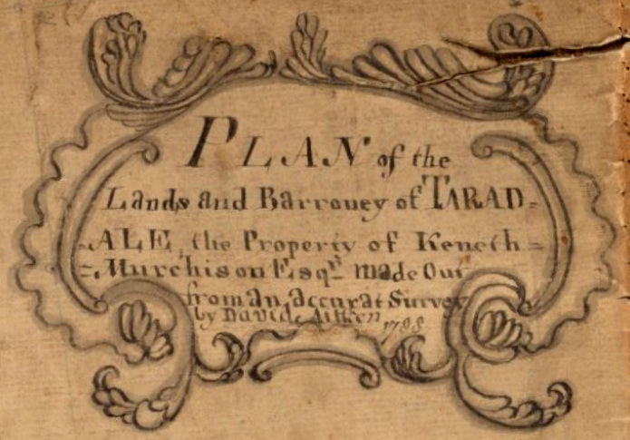
From the Tarradale plan
His titles contain his own erratic spelling – whilst spelling could be idiosyncratic in this period, I do wonder that he did not seek a second opinion on key elements like the title: “an accruate plan” does not give confidence in the care of the craftsman! And yet, the evidence from the plans themselves is that he took great care that his measurements and delineation were indeed accurate.
Care and accuracy were paramount to Peter May, and many of his letters to his assistants focus on ensuring surveying and drawing were carried out meticulously. Whilst similar letters from Aitken are not extant, nevertheless his repeat business speaks for itself.
Ian Adams believed that from commonality of technical style many of the surveyors operating in this period were connected in a kind of training family tree originating with one John Forbes, and he placed Peter May, the Taylor family (responsible for the Skinner & Taylor road maps), Sangster and Aitken all within this training dynasty.
One is sometimes tempted to read perhaps too much into the drawings on his plans, simply because they are so detailed. The direction of runrig adopted on different fields on estates at the time of survey is presumably accurate enough. Whilst he varied the size of buildings drawn on his plans to reflect the actual size on the ground, were the drawings themselves truly vignettes showing the building style? On his Findon plan, for instance, Kinbeachie House is shown as considerably larger than Culbo House, with a window in the west wall, and there is a suggestion of slating on the roof. Is this reading too much into a small sketch?

Culbo House, Resolis, drawn in 1769.

Kinbeachie House, Resolis, drawn in 1769
It is a shame that several of Aitken’s plans are now somewhat tattered, and, indeed, at least one is now deemed unfit for production. While we know about his plans in the National Records of Scotland, and some of those in the National Library of Scotland, there must be many others held elsewhere, in family papers, university archives, local museums. It would be good if these important documents by a significant early estate surveyor were digitally recorded from their various locations and grouped as an important national heritage asset.
Click here to return to the Story behind the Stone gallery
David Aitken maps and survey material
National Library of Scotland (many of these are accessible on the excellent NLS digital map website here).
- Dep 313/3584 Copy Plan of the ground and marches in dispute between Elizabeth Countess of Sutherland and John Gordon of Caroll Esq. 1 manuscript map: col.; 75 x 152 cm [There is a note by Aitken on this plan to this effect: “N:B There is deliverd allong with this Plan, Signed by the Surveyor, Siven pages in writing by way of Information Explaning the Plan to the Arbiter. D.A and that each Square in this Plan Contains Two acres”]
- Dep 313/3587/1 Volume of 27 coloured plans of farms in Skelbo surveyed by David Aitken, 1778.
- Dep 313/3587/5 Tracing of part of the Skelbo estate (no. x), by David Aitken, 1788 1 manuscript map: col.; 52 x 42 cm
- Dep 313/3617/01 Plan of the Farm of Proncy-nain, Dornoch. 1 manuscript map: col.; 49 x 39 cm
- Brora Parish
- Acc.10225/4 ‘An Exact Sketch or Plan of the Grounds and Marches in Dispute between the Right Hon. Elizabeth Countess of Sutherland and John Gordon of Carroll, Esq. Made from an Accurate Survey by David Aitken, 1772’, 1774.
- Dornoch Parish
- Acc.10225/37 ‘Plan of the Lonmore of Dornoch presently under Division between the Right Hon. the Countess of Sutherland and the other Heritors.’ Surveyed by David Aitken, 1783.
- Endorsed by Donald MacLean [sic] of Geanies, 1783. Annotated, 1899.
- With plan of Dornoch town.
- Coloured. Rolled.
- Rogart Parish
- Acc.10225/136-8 Plans of Langwell, possibly of David Aitken, ca.1770.
- Nos.xvi-xviii. Coloured.
- Plan of the Island of Tauneray, a part of the annexed estate of Coigach, made out from an accurate survey by Daivd Aitken 1784.
- courtesy of the North of Scotland Archaeological Society
- Plan of the Lands and Barroney of Drynie – the Property of Colonel Colin Graham – made out from an accurate Survey by David Aitken 1786.
- courtesy of the North of Scotland Archaeological Society
- Plan of the Lands and Barroney of Tarradale – the Property of Kenneth Murchison Esq – made out from an accurate Survey by David Aitken 1788.
- courtesy of the North of Scotland Archaeological Society
Highland Council Archive Service
- D262 David Aitken Plans of Drynie, 1786
- D263 David Aitken Plans of Findon and Tulloch Estate, 1769-1804
- D264 David Aitken Plans of Brahan and Tulloch, Ross-shire, 1763-1852
- D274 Slides and photographic copies of David Aitken plan of Tarradale, 1788
- D470 Photocopies of a plan of the lands of Erchet and Achnabat, 1764 / D590 A plan of the lands of Erchet and Achnabet by David Aitken, 1764
- NRAS1124 Duncan and Duncan, Solicitors, Dingwall, Ross-shire 1804–1923
- [includes] Plans, 1804–93; including lands of Tulloch and Dachcarty by D. Aitken, 1804
- NRAS1073/Bundle 91 Fraser-Tytler Family, of Aldourie, Inverness-shire 1667–20th century. Miscellaneous legal papers
- [includes] Estimate of value of lands and barony of Aultdowrie etc. made from surveys taken by David Aitkin in 1764, by George Brown, 1800.
Private collections
- Carnegie of Crimonmogate 1455–19th century NRAS Reference NRAS64/24
- Sketches of the moss on the barony of Crimonmogate, one by David Aitken, Surveyor, September 1768; and one by George Brown, Surveyor of Land, Aberdeen, 10 April, 1772
Orkney Library & Archive
- D13/6/14 Earldom of Orkney Estate Office Records 1688–1851
- Miscellaneous papers, extracts, letters, rentals, refers to the Mill of Frotoft, Rousay, and missionary for Flotta. Includes: – 1766 Abstract of a survey of Burray and Flotta by David Aitken, land surveyor.
- D13/ADDL/9 Earldom of Orkney Estate Office Records
- Set of five plans of lands in South Ronaldsay, showing new plankings drawn over old fields and pastures. No date, no surveyor. [But apparently by David Aitken, surveyor of land at Newtarbet, 1769 – see nos 16 and 31]
- D13/ADDL/16 Earldom of Orkney Estate Office Records
- Papers relating to the planking and division of lands in South Ronaldsay; David Aitken, surveyor of lands at Newtarbet. Includes: – 1747 Copy agreement by the Earl of Galloway and others as to planking of lands in South Ronaldsay. Text. [See plans,D13/ADDL/9 and D13/ADDL/31]
- D13/ADDL/31 Earldom of Orkney Estate Office Records 1767–1769
- Accounts and valuations by David Aitken, surveyor of land at Newtarbat, for dividing the commonties and mosses in South Ronaldsay. Text. See 9 & 16.
- SC11/5/1768/015 Sheriff Court Records: Civil Court Processes 1768
- Pursuer Details: John CROMARTIE, South Ronaldsay Nature of Action: Petition and complaint relating to division of land Defender Details: David AITKEN, Surveyor
- SC11/5/1769/058 Sheriff Court Records: Civil Court Processes 1769
- Pursuer Details: David AITKEN, His assistants, Surveyor, South Ronaldsay Nature of Action: Petition relating to threatening behaviour Defender Details: James LOUTIT, Others, Aikers
Dingwall Museum
- 1788 – a draft plan of the Muir Grounds of the Burgh of Dingwall
- The minutes of 30 June 1788 mention: “as the whole Muir Grounds of the Burgh have been surveyed by Mr Aitkin, and an exact and regular plan thereof made out by him now produced by the Clerk …”
National Records of Scotland
- RHP1046 Plan of the estate of Cromarty, Ross and Cromarty, 1764
- RHP5249 Plan of the Mains of Pulrossie, etc in possession of J Salt, Esq., 1765
- RHP92546 Copy plan of controverted marches and grazings at Duchally (Douchally) in dispute between Lord Reay and Roderick McLeod of Cadboll, 1766
- RHP1219 Plan of the lands of Brims, Thurso, Caithness, 1769
- RHP3513 Plan of the estate and barony of Findon the property of Sir Roderick Mackenzie of Scatwell, 1769
- RHP10671 Photostat copy of the plan of the farm and policy of Novar, the property of General Munro, 1777
- RHP142804 Plan of Mains of Brahan farm, Brahan estate, Ross and Cromarty, 1787
- RHP1728 Architectural drawing and estimate of houses composing the village and fishing establishment at Ullapool, Ross and Cromarty, 1787
- RHP1473 Plan of the estate of Tulloch, Dingwall, Ross and Comarty, 1789
- RHP1474 Plan of the burgh lands of the estate of Tulloch, property of Duncan Davidson, 1789
- RHP12647 Volume of plans of the estate of Pulrossie (from there to Maikle), the property of Captain John Dempster, 1790
- RHP24959 Plan of lands of Dalmore (Dallmore) and Obsdale, the property of Duncan Munro of Cullcairn, 1791
- RHP43265 Plan of proposed bridge at Cononbridge and bridge over the Orrin at Aultgowrie, Ross and Cromarty, 1801
- RHP1466 Plan of burgage lands in and about Fortrose, Ross and Cromarty [19th century]